Compras a menudo en Amazon?? Pincha aquí!!!


ViewGrip: #1 Free Youtube Views, Likes & Subscribers


Powered by Restream.io


Mostrando entradas con la etiqueta SFMTA. Mostrar todas las entradas

jueves, 5 de enero de 2023

New T Third Connecting Chinatown to Sunnydale Starts Saturday

New T Third Connecting Chinatown to Sunnydale Starts Saturday
By Christopher Ward

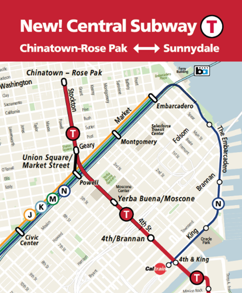
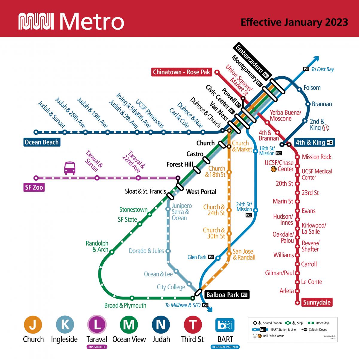
Muni Metro map effective January 7, 2023, showing the new T Third route connecting Chinatown-Rose Pak Station from 4th & King in Central Subway. Muni’s J Church, K Ingleside and M Ocean View turn around at Embarcadero Station; the N Judah continues along the Embarcadero to Embarcadero & Folsom, Embarcadero & Brannan and 2nd & King and onto 4th & King.New Muni Metro map.

This Saturday the T Third starts its long-awaited new route connecting Chinatown-Rose Pak Station from 4th & King in Central Subway, Mondays through Fridays, 6 a.m. to midnight every 10 minutes and Saturdays and Sundays, 8 a.m. to midnight every 12 minutes.  

The K Ingleside will now travel between Balboa Park and Embarcadero Station. Customers using Embarcadero & Folsom, Embarcadero & Brannan and 2nd and King platforms should transfer to the N Judah at Powell Station or 4th & King.

Watch the new Muni Metro service map animations.

The following bus service changes also start this Saturday:

  • The T Third Bus will now run along 3rd and 4th Streets in SoMa and on Stockton Street north of Market Street to align with the new T Third rail line and will no longer travel on the Embarcadero and Market Street. 
  • The 6 Haight/Parnassus will now run until 12 a.m. daily instead of 10 p.m. to cover the service gap on Haight Street.
  • The 21 Hayes will now run to Fulton Street and 8th Avenue on weekdays after 7 p.m. and weekends all day to provide access to Golden Gate Park. There will be no additional stops between Stanyan Street and 8th Avenue.
  • The terminals on the 12 Folsom/Pacific and 36 Teresita are changing to provide better operator relief points, with minor reroutes near Cesar Chavez and Valencia Streets.
  • Service will be added on 28 19th Avenue and 38R Geary Rapid to help reduce crowding.
  • The bus stops at 4th and Folsom streets and 4th and Howard streets will be consolidated into one stop in front of the new Yerba Buena/Moscone Station to provide better connections for customers as part of 4th Street Improvement Project.

Customers traveling to stops along the Embarcadero or the baseball stadium at 2nd & King should use the N Judah.

Customers going to Sunnydale should catch the new T Third at the new Union Square/Market Street Station.

Watch how to get around with our video, Connecting Communities: How to Navigate the Central Subway. 

For more travel and connections tips read our Frequently Asked Questions.

The new Central Subway tunnel runs underneath the Market Street subway, which means the stations are deeper and have very long escalators – the longest in the United States west of the Mississippi. There are also two glass elevators at each station from street level to concourse level and from concourse level to platform level for accessibility.

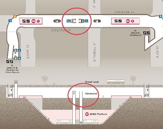
At Union Square/Market Street Station, the elevators are in the center of the concourse with their own fare gates.

MuniMobile and Lifeline customers may use any of the wide fare gates at the Union Square/Market Street Station – at the Geary escalators, the Ellis escalators or the elevators in the center of the concourse.

WiFi Connectivity in the New Subway Stations

All three new Central Subway underground stations are equipped with WiFi, and cellular service will be set up soon. To connect to the free, open WiFi network, open your phone’s WiFi settings and select #SFWiFi and enjoy connectivity on all station platforms and concourse levels.

To report WiFi connectivity issues please take note of the exact location in the station where the signal is low or nonexistent and call 311 You can also write to us here with any feedback or questions.

Enjoy your ride on Muni!


Published January 06, 2023 at 01:31AM
https://ift.tt/DUmlfOJ

miércoles, 4 de enero de 2023

Ride to Chase Center Events Along the New T Third

Ride to Chase Center Events Along the New T Third
By Christopher Ward

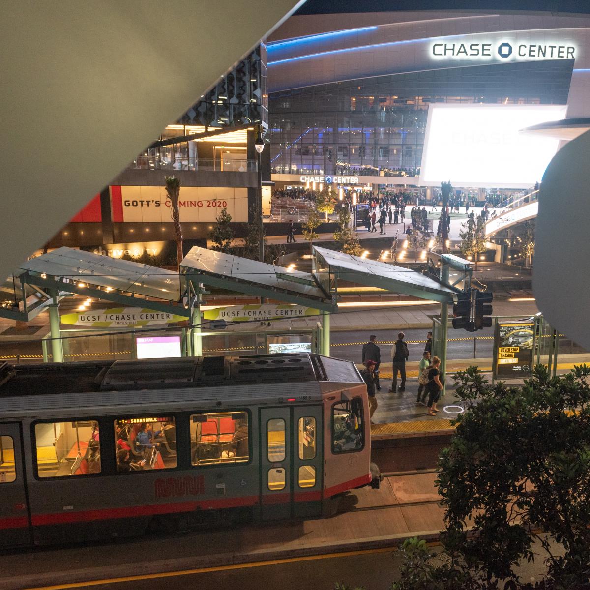
 Photo of a Muni Metro train at the UCSF/Chase Center platform with Chase Center in the background.

Starting January 7, take the S Shuttle Mission Bay on the new T Third line via Central Subway to Chase Center events.

Service on the new T Third Line from Chinatown Rose-Pak to Sunnydale starts January 7. With it, new event service to Chase Center will also start via Central Subway on the S Shuttle Mission Bay.

During events at Chase Center, shuttles will operate between Chinatown-Rose Pak Station and UCSF/Chase Center every 10 minutes. These shuttles will start approximately two and a half hours before an event and continue for two and half hours after an event.

From Chinatown to Chase Center, riding the S Shuttle Mission Bay takes about 20 minutes. Best of all, your Chase Center event ticket is your Muni fare. No additional Muni fare needed!

  • Both electronic and physical tickets for events – including Warriors games, concerts and other events – will serve as proof of payment for Muni service throughout the day.
  • The ticket will be valid all day and expire at the end of the service day at 2 a.m. after the event.
  • Passengers with a valid ticket can board through any door so we can quickly get you to the event or game! There is no need to show your Chase Center ticket to a bus or rail driver.
  • Keep your event ticket handy for proof of ticket purchase. To avoid fines, you will need to show your valid event ticket as proof of purchase if requested by a Transit Fare Inspector.

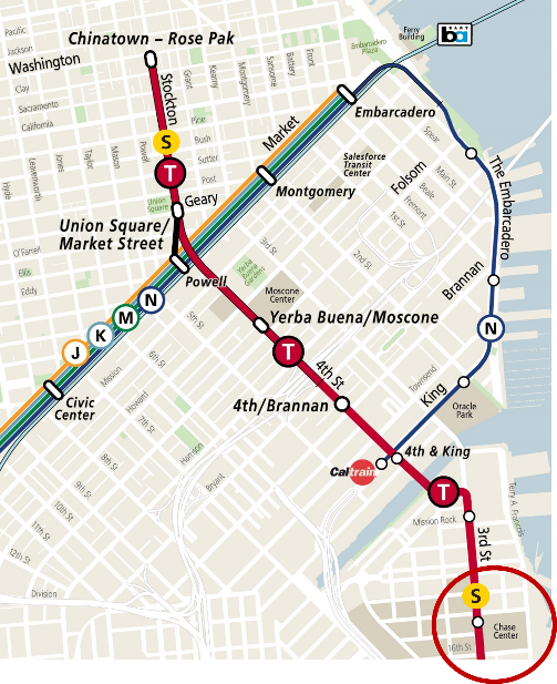
Map showing the new alignment of the T Third to Chinatown-Rose Pak Station, connecting from 4th and King streets and continuing north to Central Subway; existing Muni Metro system's J Church, K Ingleside and M Ocean terminating at Embarcadero Station; the N Judah continuing along the Embarcadero to Embarcadero & Folsom, Embarcadero & Brannan and 2nd & King and onto 4th & King; S Shuttle service between Chinatown and Chase Center.

The S Shuttle Mission Bay will operate between Chinatown-Rose Pak Station and UCSF/Chase Center during Chase Center events.

Muni Metro and BART customers can transfer at Powell Station underground to Union Square/Market Street Station and board the S Shuttle Mission Bay southbound to the UCSF/Chase Center Station. At Union Square/Market Street Station, elevators to the platform are in the center of the station with their own fare gates.

Customers traveling past Chase Center should board trains with head signs that say “T Third Sunnydale” to avoid transferring at Mission Bay.

The 78X 16th Street Arena Express will continue to run express service between Chase Center and the 16th Street BART station two and a half hours before events and one hour after events.

Visit our Chase Center webpage (SFMTA.com/ChaseCenter) for more information.


Published January 05, 2023 at 01:01AM
https://ift.tt/OuZTb8a

martes, 3 de enero de 2023

How To Navigate Transfers on the New T Third

How To Navigate Transfers on the New T Third
By Mariana Maguire

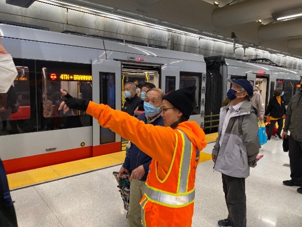
SFMTA Ambassador talking to customers on Metro station platform.

SFMTA Ambassadors are helping customers navigate the new Central Subway stations and Metro service changes.

As we prepare for the start of new T Third service on Saturday, January 7, between Sunnydale and Chinatown-Rose Pak Station, here are some important travel tips to help you plan your new connections.

Map showing the new alignment of the T Third to Chinatown-Rose Pak Station, connecting from 4th and King streets continuing north to Central Subway. Existing Muni Metro J Church, K Ingleside and M Ocean View terminating at Embarcadero Station. The N Judah continues along the Embarcadero to Caltrain at 4th and King streets.

New T Third service via Central Subway starts January 7 with service between Sunnydale and Chinatown-Rose Pak Station.

For J Church, K Ingleside, M Ocean View Customers

  • For stops along the Embarcadero and King Street including 2nd & King (Oracle Park) and 4th & King (Caltrain), take the N Judah.
  • For service north to Chinatown-Rose Pak Station or south to Yerba/Buena Moscone Station, 4th & King streets (Caltrain), UCSF/Chase Center and beyond to Sunnydale, transfer at Powell Station to Union Square/Market Street Station and take the new T Third. The N Judah will also continue to serve 4th & King (Caltrain).

For T Third Customers

  • For service to Balboa Park, transfer at Union Square/Market Street Station to Powell Station and take the K Ingleside westbound. Or take any westbound J Church or M Ocean View.
  • For service to 2nd & King (Oracle Park) and stops along the Embarcadero, take the N Judah at 4th and King streets, next to the Caltrain station.
  • For service to all Market Street Metro stations, transfer at Union Square/Market Street Station to Powell Station and take the K Ingleside and M Ocean View for Embarcadero to West Portal Stations or take the N Judah and J Church for Embarcadero to Van Ness Stations.

Bird’s eye view and cross-sectional station layout map of Union Square/Market Street Station emphasizing elevators in the center of the station connecting the concourse and platform levels.

Elevators to trains at Union Square/Market Street Station are located in the middle of the concourse with their own fare gates.

Accessibility at New Union Square/Market Street Station

The new Central Subway stations are more accessible to riders with disabilities, with level boarding between the train and platform and two glass elevators between each level for more reliability, light and visibility. Once service between Chinatown-Rose Pak and Sunnydale starts January 7, use our Elevator Status Page to help you plan your trip.

Here are a few key tips to consider if you are taking the elevators at the new Union Square /Market Street Station

  • Elevators between street level and the concourse are located at two locations:
    • The new station entrance at Geary and Stockton, at Union Square.
    • The existing BART and Muni elevator on Market and Stockton streets. Exit the elevator to the left at concourse level and follow signs to Union Square/Market Street Station.
  • The first set of fare gates at both entrances to the Union Square/Market Street Station lead to a long set of escalators. The elevators from concourse to platform level are in the center of the concourse with their own fare gates.

Find additional information about new connections and wayfinding in our new T Third service Frequently Asked Questions.


Published January 04, 2023 at 02:19AM
https://ift.tt/xUE3BHc

lunes, 19 de diciembre de 2022

Upcoming Capacity Indicators

Upcoming Capacity Indicators
By Christopher Ward

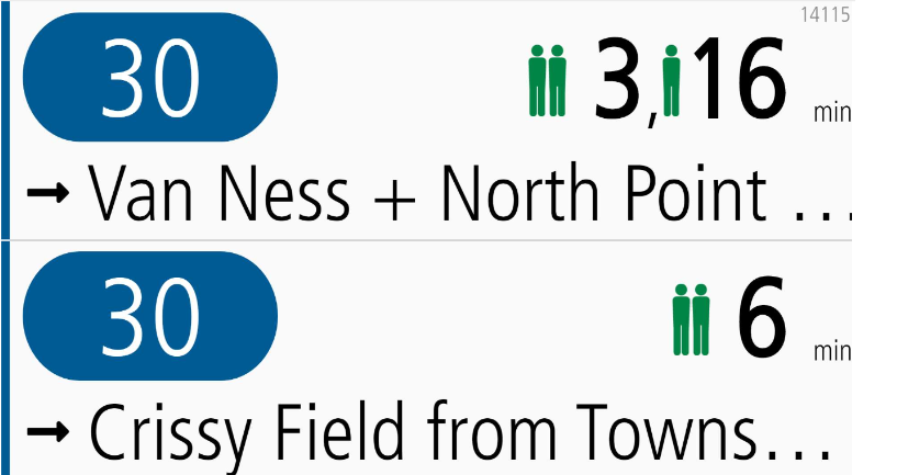
Image of new stick figures indicating bus capacity on shelter signs.

Next Generation Customer Information displays will show capacity indicators: One figure means there are many seats available. Two figures indicates that there are likely a few empty seats available. Three figures tell you that there’s likely only standing room available.

The SFMTA continues expanding trip planning and accessibility features and improving Muni predictions. This is part of the ongoing Next Generation Customer Information System (CIS) project. One of the newest features is a capacity indicator.

A capacity indicator helps customers understand how much space is available on vehicles. Customers can see the indicator on our Next Generation displays in the bus shelters and on train platforms. Customers may use this information to make travel choices. For example, customers can choose to wait for a less full vehicle or take an alternative route.

As of November 2022, Muni vehicles equipped with automatic onboard passenger counters send capacity information to our Next Generation CIS. This information is now shown symbolically with stick figures. One figure means there are many seats available. Two figures indicates that there are likely a few empty seats available. Three figures tell you that there’s likely only standing room available.

Customers should always yield the priority seating area for people with disabilities, older adults, and pregnant persons.

We’re excited to finally bring these features to our customers and build a system that will help make Muni travel even more efficient, reliable and enjoyable.


Published December 20, 2022 at 12:08AM
https://ift.tt/IdArp1U

miércoles, 14 de diciembre de 2022

Central Subway Brings More Art to Union Square

Central Subway Brings More Art to Union Square
By Enrique Aguilar

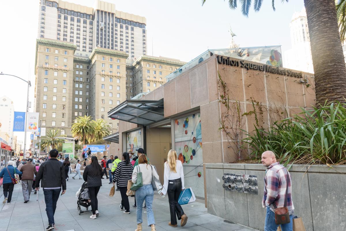
Street view of a station entrance and downtown buildings with dozens of pedestrians holding various items

Main entrance to Union Square/Market Street Station during special weekend service 

The Union Square/Market Street Station is centered in the heart of the Union Square neighborhood, known for world-class shopping and notable art galleries. With the opening of the Central Subway, a new public art collection arrived, with color schemes complementing the station’s modern architectural design. Collaborations between artists reign at this station, allowing a blend of different artistic concepts. 

  • Erwin Redl titled his piece Lucy in the Sky. It is an illuminated installation comprised of hundreds of translucent 10 x 10 inch light panels, each containing an array of color LEDs. A diamond-shaped pattern is formed by suspended light panels along the entire length of the concourse level corridor’s ceiling. They are computer programmed to slowly change color and display simple patterns, creating an immersive and kaleidoscopic experience.  

  • Jim Campbell and Werner Klotz created a site-specific stainless-steel sculpture called Silent Stream, located on the station’s platform level. Comprised of highly polished steel disks, the overhead installation loops its way through the struts along the length of the platform and reflects the passengers and trains passing below.  

  • Amanda Hughen and Jennifer Starkweather integrated a design into the glass deck and the front faces of the glass elevator enclosures. Titled Convergence: Commute Patterns, the artwork is based on the dynamic and diverse pathways, commute patterns and arterial structures above and below the streets of the Bay Area. The artwork’s visual impact on the station’s exterior alternates from being subtle during the day to backlit at night.  

Watch an interview video with comments from Amanda Hughen, Jennifer Starkweather, Erwin Redel, Jim Campbell and Werner Klotz. Get to know the artists and learn directly from them about their work at the new Union Square/Market Street Station. A special thank you to the San Francisco Arts Commission for making public art possible at the four new stations. 

Special Weekend Service started on Nov. 19 and will last through the end of the year, Saturdays and Sundays from 8 a.m. to midnight. Full revenue service will begin January 7, Monday through Friday, 6 a.m. to midnight and Saturdays and Sundays, 8 a.m. to midnight. 

For more artist information: 


Published December 15, 2022 at 01:24AM
https://ift.tt/TwInLmt

viernes, 9 de diciembre de 2022

Public Artwork Unveiled Inside New Station in Yerba Buena

Public Artwork Unveiled Inside New Station in Yerba Buena
By Enrique Aguilar

Have you had a chance to explore the Central Subway's new stations? Special weekend service is Saturdays and Sundays, from 8 a.m. to 12 a.m. midnight, through the end of the year. Ride the trains and be mesmerized by beautiful artwork at each new station. 

Muni customers will encounter public art when using the four new Central Subway stations to reach their destinations. The art was commissioned by the San Francisco Arts Commission and funded by the City’s Art Enrichment Ordinance, which allocates 2% of the total eligible costs of public works projects for public art. Public art helps draw out the identity of a space, aids in understanding a neighborhood's historical or cultural significance, and builds a connection between the visitor and surrounding community. 

The Yerba Buena/Moscone Station includes artwork by Catherine Wagner, Leslie Shows and Roxy Paine. The installations can be found on the station's surface and concourse levels. 

  • Catherine Wagner transformed photographs she took in the late 1970s that document the monumental construction of the George Moscone Convention Center, and focus on ideas of transformation. Titled Arc Cycle, the artwork reproduces several iconic images from this photographic series, translating them into laser-etched granite at the concourse level, and art glass at the station’s entry.  

  • Leslie Shows created Face C/Z, installed in the ticketing hall on the concourse level. Based on an image of iron pyrite made with a consumer grade scanner, the artwork was hand fabricated in a unique style combining mirrored, fused, painted, and engraved glass, sheet metal, and other permanent materials The pyrite (or "fool's gold") image speaks to ever-shifting notions of value in industry and aesthetics, the many historical "gold rushes" of California, and the idea that anything might be made valuable under the right circumstances.  

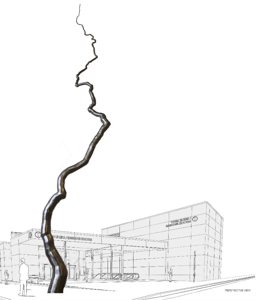
  • Roxy Paine created a monumental, 110 feet tall sculpture for the public plaza at 4th and Clementina streets outside of the station. Titled Node, the artwork is conceived to emerge from the complex manmade structures existing beneath the sidewalk, including the subway, communication networks, electrical and water supply, and waste systems that are all lifelines of a functioning city. According to Paine, the sculpture is "an elegant line connecting earth to sky, people to underground systems, and sculpture to city." Node is expected to be installed in early 2023. 

Rendered image of an art node piece in front of a building with a person in the foreground

Mockup of art installation on the station's plaza

Watch an interview video with artists Leslie Shows and Catherine Wagner to learn more about their inspiration for their work on display at the new Yerba Buena/Moscone station. A special thank you to the San Francisco Arts Commission for making public art possible at the four new stations. 

Full revenue service will begin January 7, Monday through Friday, 6 a.m. to midnight and Saturdays and Sundays, 8 a.m. to midnight. 

Stay tuned for additional blogs showcasing public art at the other new Central Subway stations. 

For more artist information:


Published December 10, 2022 at 12:35AM
https://ift.tt/8j7Dacb

Hop Onboard Muni and Enjoy Downtown Union Square

Hop Onboard Muni and Enjoy Downtown Union Square
By Pamela Johnson

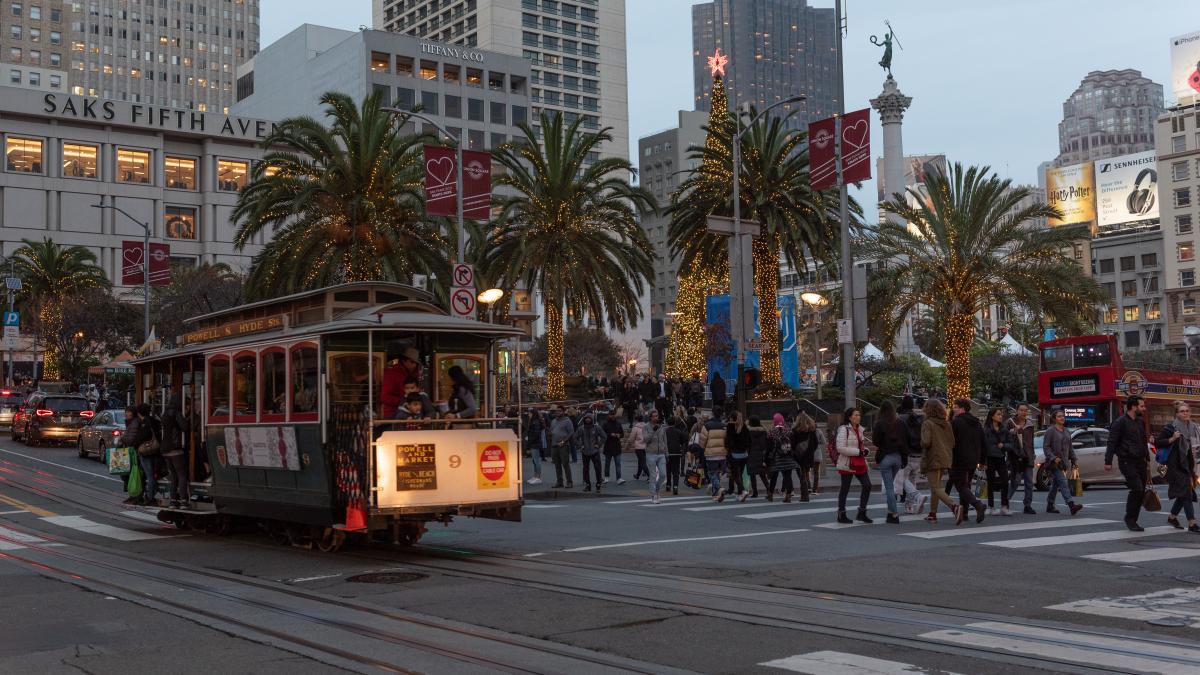
A filled Cable Car at a busy intersection in Downtown San Francisco decorated in holiday festivities with dozens of shoppers and vehicles

The iconic Cable Cars are just one of the many options to get you to all the holiday festivities in Downtown Union Square!

The SFMTA would like to wish you a Happy Holidays! With festivities, dining, shopping and all the many holiday activities to choose from, Downtown Union Square, much like the rest of the city is making optimistic strides in the city’s economic recovery. Catching Muni, paratransit or a taxi to downtown supports small businesses and is a big boost to our transit goals. Below is a comprehensive list of transit and parking options to head into the heart of the downtown shopping and festivities this holiday season.  

Central Subway Special Weekend Shuttle 

Muni Metro Light Rail  

Muni Bus Lines 

Cable Cars 

  • Invented here nearly 150 years ago and named a National Historic Landmark in 1964, hop on any of our beloved world famous Cable Cars this season. Be sure to lookout for several Cable Cars decorated in the spirit of the holidays by our dedicated and talented staff. Passengers will travel up and down the hills of San Francisco in this annual holiday tradition.  

Additional Services  

  • Free One-Hour Parking at Union Square Garage - the Mayor will be providing one-hour of free parking at our Union Square garage through the end of the year, regular posted rates apply thereafter. All facilities have increased staffing and security, restriped its parking spaces, and upgraded much of its overhead lighting, to make parking easier and safer this holiday.   

  • Additional SFMTA parking garages - Ellis O’Farrell, Sutter-Stockton and Fifth & Mission / Yerba Buena 

  • If you drive, parking in a city-owned garage may be the way to go. And parking rates at city-owned garages are typically 40% less expensive than parking prices in privately-owned garages.  

  • Taxi - with knowledgeable and trustworthy drivers, save some gas and catch a taxi. You’ll not only ride in a clean and safe vehicle, your taxi can use our red transit-only lanes to get to your destination quicker. And since November 9, the Taxi Upfront Fare Pilot Program has been helping customers book a taxi trip through a taxi e-hail app and pay a flat-rate, upfront fare.  Being able to request a taxi through approved third-party apps provided customers with upfront information about their fares, relieve meter anxiety and allow customers to price shop for similar on-demand services.

  • Essential Trip Card - older adults, people with disabilities and other eligible participants can benefit from this discount program paying 20% of the cost of a regular cab. Don’t forget our Shop-a-Round program, a convenient, low-cost shuttle that makes it easier to go grocery shopping for all your holiday meals. The shuttle takes groups of riders to grocery stores or supermarkets in San Francisco where they want to shop. The service offers registered older adults and people with disabilities personalized assistance that is not available on Muni bus and rail lines. 

  • SF Paratransit - is a van and taxi program for people unable to independently use or access public transit because of a disability or disabling health condition. Participants may also use their Essential Trip Card for this service.  

For real-time updates, follow us on https://twitter.com/sfmta_muni or visit SFMTA.com/EmailText to sign up for real-time text messages or email alerts. 

For details of Muni re-routes, visit SFMTA.com/Updates. This website will be updated when it is closer to the event date. 

For additional notifications and agency updates, subscribe to our blogs, daily or weekly updates. 


Published December 09, 2022 at 07:20PM
https://ift.tt/pJUDbTr

miércoles, 30 de noviembre de 2022

A Brief History of the T Third Part 1: 1860-2007

A Brief History of the T Third Part 1: 1860-2007
By Jeremy Menzies

Earlier this month, we launched free weekend shuttle service in the Central Subway. And come January 7th, our 4 new stations will connect directly to the rest of the T line from Sunnydale to Chinatown. Through this two-part blog series, we will look back at some of the history of the T from the 1860s to today!

In Part One, we’ll look over the first 150 years from the 1860s to the 2000s. Next month in Part Two, we will take a closer look at the history of the T and Central Subway projects leading up to today’s service. 

The Horsecar Era: 1860s-1890s 

Starting in the 1860s, transit service along today’s T Line was provided by horsecars. These were small rail cars (that looked much like a cable car) that were pulled along tracks by horses. Two companies, the Omnibus Railroad and the North Beach & Mission Railway, operated horsecar lines on parts of the path of today’s T. These lines were mainly meant to connect North Beach with the 3rd and 4th street corridors as far south as about Townsend Street. 

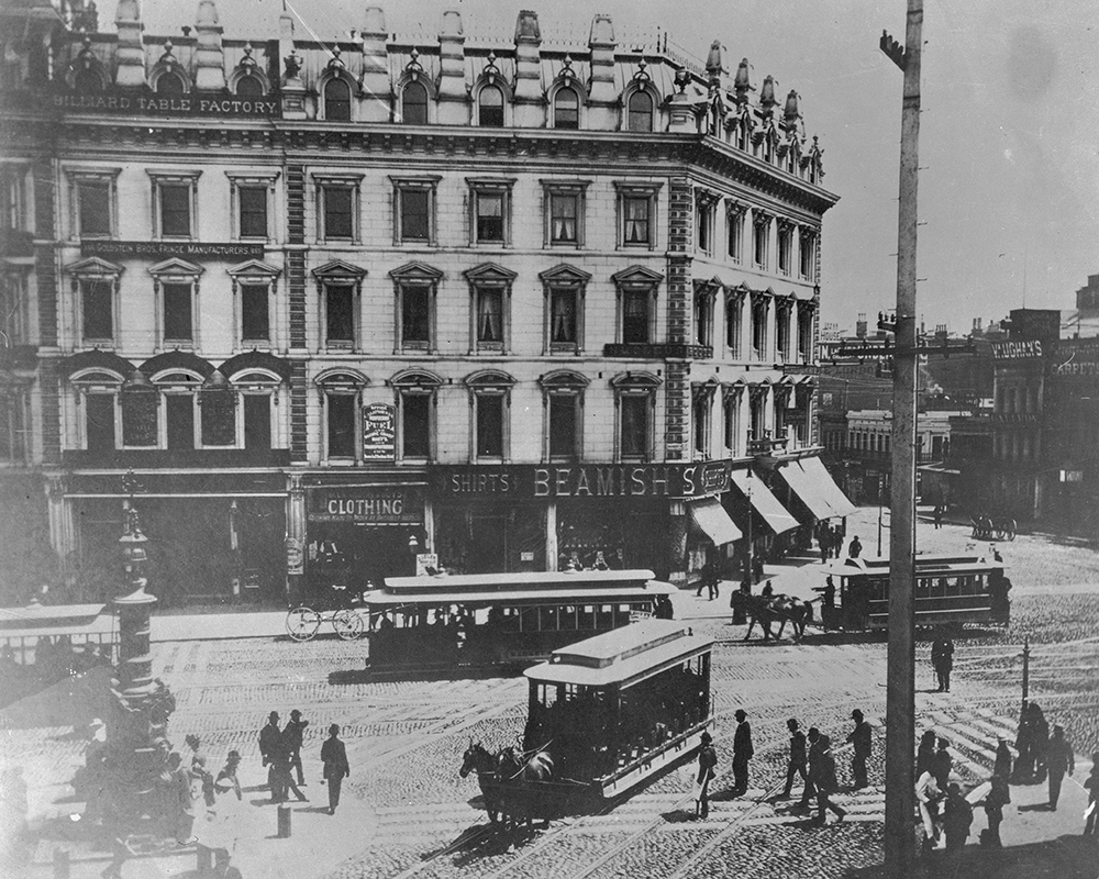
Image of a busy intersection from the 1890's with horse drawn streetcars, pedestrians and a department building are seen

This photo circa the 1880s shows the busy intersection of Kearny, Geary, 3rd and Market streets, looking south to 3rd.  In the foreground is a horsecar running up Kearny from 3rd. 

Further south on 3rd (then called Kentucky Street), horsecars were operated by the Potrero & Bay View Railroad. Here the route ran over two bridges across Mission Bay and Islais Creek (known as “Longbridge”), ending near today’s 3rd & Gilman. This route served the industrial heart of San Francisco and opened up development in the Bayview but was not very profitable because of its length. 

The Electric Streetcar Era: 1890s-1940s 

The 1890s marked the dawn of the electric streetcar era in San Francisco. A new technology, electric-powered cars could carry more people over longer distances faster than both horse and cable cars. On top of that, they were cheaper to operate and increased profit potential for transit companies. 

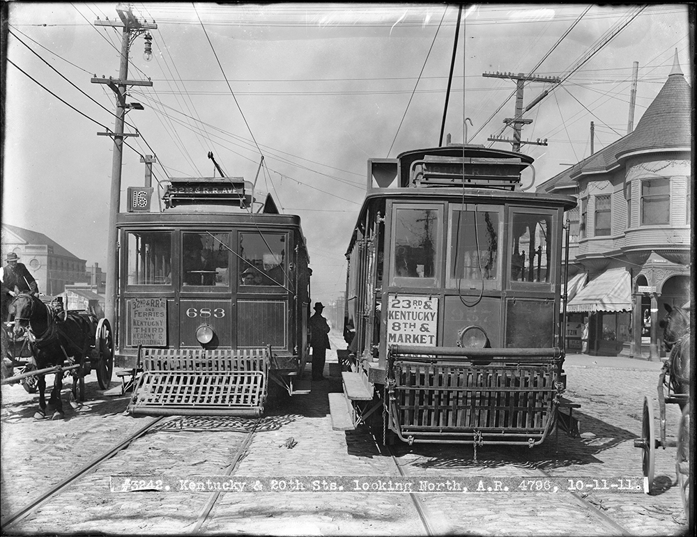
Two streetcars from 1911 shown with a person seen in the middle as well as a horse drawn carriage on the side

This 1911 photo shows two cars passing at 3rd (Kentucky) and 20th streets. On the left is a 16 Line car running to its terminal in the Bayview. At right is a 30 Line car heading north to 8th and Market. 

In 1894, the first electric streetcar line began operating along parts of today’s T Line. Known as the 3rd & Kearny Line, it followed much the same route as the early horsecars from North Beach to the Southern Pacific Railroad Depot on Townsend Street. It was extended into the Bayview to 3rd and Palou and eventually was reformed into the 15, 16, and 29 Lines. Each of these served a different portion of the corridor covering differing needs of riders travelling through downtown or all the way out to the Bayview. 

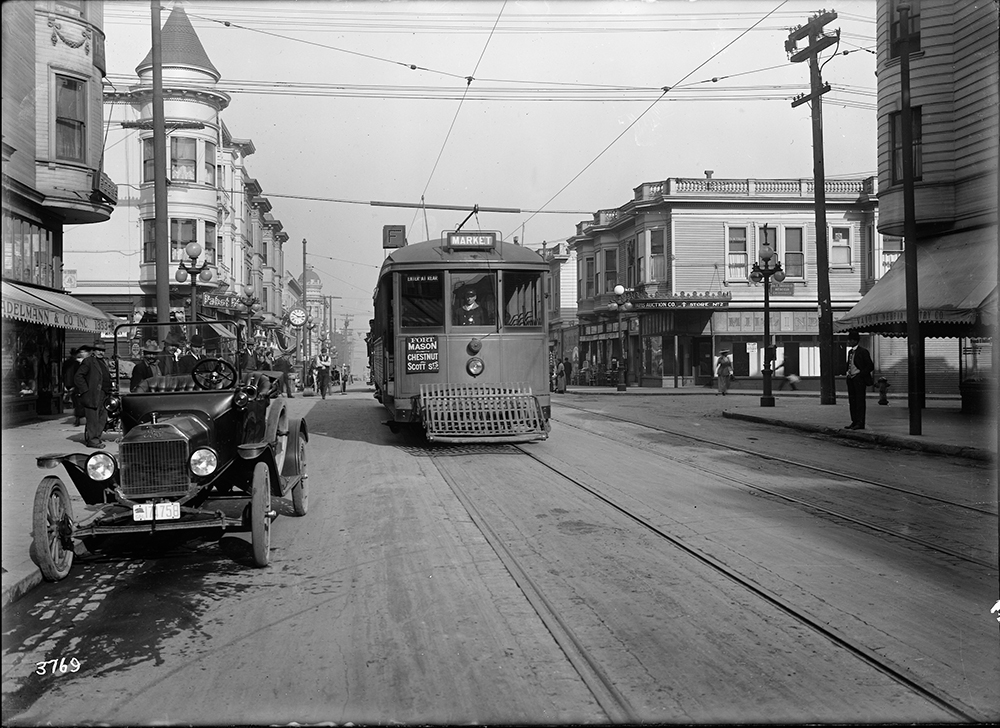
An old streetcar seen on the mainline with a few parked vehicles along the sidewalk and sundry stores in the background

A Muni F Stockton streetcar passes Vallejo Street in this photo from 1916. 

Muni’s first streetcar line to serve a similar route to the Central Subway portion of the T was the F Stockton, which opened for the 1915 Panama Pacific Exposition. The F Line ran along 4th and Stockton streets to serve South of Market, Union Square, Chinatown and North Beach before heading out to end at Chestnut and Scott streets. 

Buses along the Bay: 1950s-2000s 

Following World War II, the 3rd Street corridor was among the many that saw transit service shift from streetcars to buses. By 1951, the 15 Kearny route served much of the area once covered by the 15, 16, and 29 streetcar lines.  

Cars and buses seen traveling during the busy commute on a congested street.

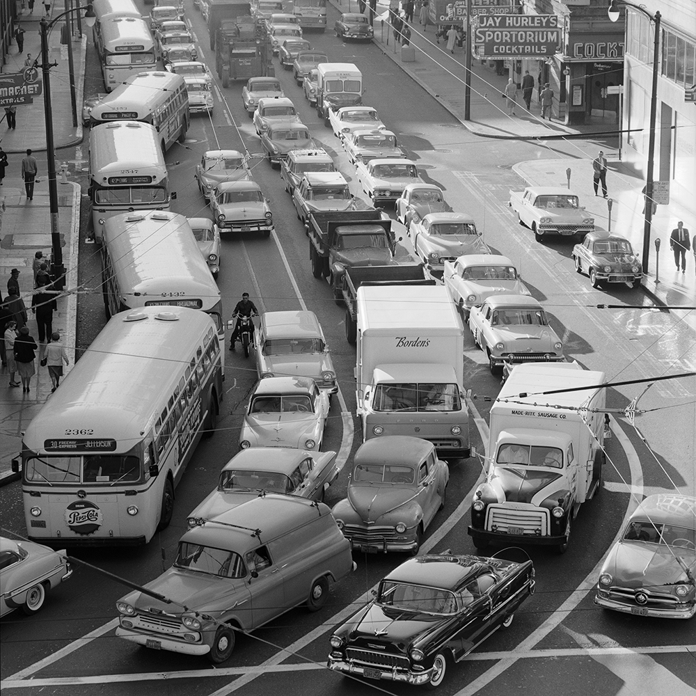
Buses on the 30, 15 and 42 fight the morning rush northbound on 3rd Street in this 1959 photo. 

Traveling along portions of today’s 8 Bayshore and T Third, the 15 route went from Powell and Jefferson streets all the way to Geneva and Mission. Eventually, it was extended to City College on Ocean Avenue. While not the only route to serve the area, the 15 carried the bulk of the load for people wishing to travel along this corridor. 

On Stockton Street, the 30 Stockton bus took over for the F, following the same route through Chinatown, Union Square, and South of Market to 4th and Townsend streets. 

An articulated bus and coach seen traveling on a busy street

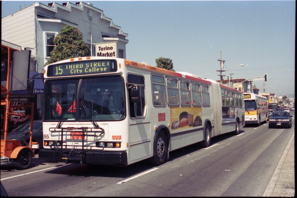
Many long-time riders will recognize this view of a 15 bus on 3rd & Palou. Discontinued with the opening of the T Line in 2007, the 15 was revived as the 15 Bayview-Hunter’s Point Express in 2021.  

Tune in next month for a closer look at the history of the T Third and Central Subway Projects. 


Published December 01, 2022 at 01:08AM
https://ift.tt/VBiQrsc

lunes, 21 de noviembre de 2022

The Future of Slow Streets

The Future of Slow Streets
By Eillie Anzilotti

Over the past two years, Slow Streets have shown how simple designs that prioritize people can transform streets. Suddenly, streets across San Francisco filled with the sounds of kids playing and neighbors chatting. They filled with people on bicycles and people rolling in wheelchairs; with joggers and dog-walkers. The streets came to life.

Initially, the SFMTA introduced Slow Streets as an emergency response to COVID-19. People needed space for recreating at a safe distance outdoors. And with Muni service reduced or suspended at the time, people needed ways to travel to essential destinations on foot or bike. To quickly meet these early pandemic needs, we implemented Slow Streets with simple signs and barricades.

Over time, it became clear that Slow Streets served an even larger purpose. They became places for communities to come together. Neighbors organized events like scavenger hunts and Trick or Treat parties around their local Slow Streets. They created art and hosted pop-up musical performances. For many people, Slow Streets encouraged them to shift their lifestyles. Some families sold their cars and began to travel by cargo bike. Older San Franciscans rediscovered the joy of riding bicycles. Fleets of kids gathered to bike to school in organized “bike buses” across the city. Beyond the initial pandemic response, Slow Streets proved critical to meeting some of San Francisco’s most significant goals: Vision Zero and Climate Action.

As the city moves out of the pandemic, it’s clear that Slow Streets have a place in San Francisco. We need to continue to encourage active transportation to meet our goal of 80% low-carbon trips by 2030—and we need to make these trips safe and accessible for people of all ages and abilities. Low-stress streets, like Slow Streets, create transportation choices for a wide range of San Franciscans by making active transportation comfortable, safe, and joyful.

On December 6, our Slow Streets team will bring a proposal for an ongoing Slow Streets program to the SFMTA Board. This post-pandemic program will maintain the same core principles as the pandemic-response Slow Streets. Its goal is to create safe, shared corridors that prioritize people traveling by active modes and making local trips by vehicle. But it will improve on the COVID-response program in some key ways. The proposed program will have a more durable, diverse design toolkit that will include traffic calming features like speed humps, traffic diversion, roadway narrowing, and improved wayfinding signs. And it will use data to make sure that streets are working effectively.

Our goal is for Slow Streets to meet or exceed national standards for low-stress corridors: streets where people of all ages and abilities feel comfortable walking and biking. That means no more than 1,500 vehicles per day, and speeds lower than 20 mph. For each Slow Street, our team will develop a design that reflects specific needs and conditions. We will also gather and analyze data on important safety measures like vehicle volumes and speeds, and adjust designs when needed. We aim to work efficiently and in collaboration with communities to implement these corridors.

Following the meeting on December 6, we will be sharing updated guidelines for using Slow Streets—whether you bike, roll, walk, or drive. These guidelines will create shared understanding for how to behave on Slow Streets to make sure everyone feels safe and welcome. More to come on this soon, but in the meantime, remember: Everyone is welcome, and please go slow!

Initially, we’ll be proposing 15 corridors for inclusion in the program. Most of these streets were COVID-Response Slow Streets that met criteria for continuing them as Slow Streets: high volumes of people walking, biking and rolling, and connections to the citywide active transportation network. Proposed Slow Streets are:

  • 12th Avenue
  • 22nd Street (proposed as an alternative to 20th Street to align with the citywide bicycle network)
  • 23rd Avenue
  • Arlington Street
  • Cabrillo Street
  • Cayuga Avenue (proposed as a new corridor)
  • Clay Street 
  • Golden Gate Avenue
  • Hearst Avenue 
  • Lyon Street
  • Minnesota Street
  • Noe Street
  • Sanchez Street
  • Shotwell Street
  • Somerset Street

Lake Street, which was already approved as a long-term Slow Street by the SFMTA board, will also be discussed by the board at the December 6 meeting. Existing Slow Streets that are not approved by the SFMTA Board will be removed following the meeting.  While the Slow Streets in SoMa are not recommended to continue as a part of the ongoing program, the existing traffic calming and local access restrictions will remain in place to encourage the use of these streets as places for community activation.

This is just the beginning of a program that we intend to grow to meet neighborhood and citywide transportation needs, in partnership with communities. An ongoing Slow Streets program for San Francisco will help our city meet its adopted goals for mobility, safety and climate action—and ensure that San Franciscans can continue to reimagine how their streets can serve them. We look forward to beginning this process and sharing more in the future.

For more information, please see the Slow Streets Fall 2022 Project Update and Frequently Asked Questions.


Published November 21, 2022 at 09:00PM
https://www.sfmta.com/blog/future-slow-streets

viernes, 18 de noviembre de 2022

Starting Tomorrow! Central Subway Special Service Opens

Starting Tomorrow! Central Subway Special Service Opens
By Mariana Maguire

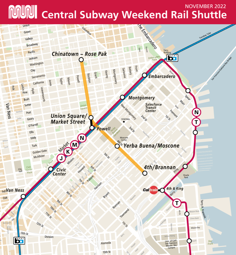
Map showing the existing Muni Metro system's J Church, K Ingleside, L Taraval Bus, M Ocean View, N Judah and T Third lines with the new Central Subway connecting at Powell Station. The Central Subway goes to Chinatown-Rose Pak Station at Stockton and Washington, Union Square/Market Street Station at Geary and Stockton, Yerba Buena/Moscone Station at 4th and Folsom and 4th & Brannan Station at 4th and Brannan

Central Subway special weekend service starts November 19 with shuttle trains between Chinatown-Rose Pak Station and 4th and Brannan.

Starting tomorrow, November 19, the four new Central Subway stations will open to the public with free special service, Saturdays and Sundays only, from 8 a.m. to 12 a.m. every 12 minutes.

This is a special opportunity for customers to ride between the new stations and get to know them before the service change in January.

To experience Central Subway special service, transfer at Powell Station from Muni Metro and BART by walking underground to the new Union Square/Market Street Station.

SFMTA Ambassadors will be on hand to help customers navigate the new stations. Looks for our bright orange SFMTA Ambassador vests, hoodies and hats!

At Chinatown-Rose Park Station, customers should listen to announcements and watch the displays for incoming train information. Trains may come into the station from either side.

In addition, displays will indicate train departures. This is because Chinatown-Rose Pak Station is the end of the line, and trains may layover for a few minutes for operators to take relief breaks.

From everyone at SFMTA, we are excited to share these new stations with you as we continue to prepare to link T Third Metro service between Sunnydale and Chinatown in January!


Published November 19, 2022 at 02:04AM
https://ift.tt/YvhPfeo

jueves, 10 de noviembre de 2022

SFMTA Upgrades Predictions Software This Weekend!

SFMTA Upgrades Predictions Software This Weekend!
By Mariana Maguire

SFMTA will switch over to a new, upgraded software system on Sunday, November 13,  as part of our Next Generation Customer Information System (CIS) project. The new software was developed to improve the way our different information systems communicate with each other and share data to and from multiple sources. This will provide customers more accurate, timely, reliable Muni service predictions. This is one more important step in the overhaul of our CIS that will enable us to provide better service to Muni customers.

SFMTA’s Next Generation CIS software has been in preliminary testing for months, and if all works well, Muni customers should not notice any change. But anyone who’s had to help loved ones with computer or smartphone troubles knows that software updates aren’t always smooth. Unanticipated challenges may arise. Customers should expect some glitches as we make the software switch and work out issues on the back end.

To reduce impacts to customers, we are gradually connecting new screens to the new software system. This should help isolate any issues to troubleshoot more effectively. Our Customer Information System staff and software contractors will be keeping a close eye on system performance and working quickly to resolve issues.

This upgrade to a new, more efficient software system is a crucial milestone toward providing many new features over the coming months, including:

  • Dynamic maps
  • Real-time service changes
  • Short-term route changes
  • Terminal departure predictions
  • Transfer connection predictions
  • Regional connections
  • Alternative routes
  • Accessibility information
  • Vehicle crowding predictions

Third Party Apps

SFMTA provides open-source transit data that third party transit apps use on their platforms. Each app has its own way of processing that information, which can vary and may lead to differences or inconsistencies in transit information. SFMTA is in touch with known third party apps to help them troubleshoot issues.

We appreciate Muni riders’ patience as we continue our Next Generation CIS upgrades to improve Muni service long-term.

Learn more about what’s next for our Next Generation upgrades and the many new features rolling out soon.


Published November 10, 2022 at 10:59PM
https://ift.tt/tSCys4Q

miércoles, 2 de noviembre de 2022

Over Half Next Generation Muni Shelter Displays Installed with More Upgrades Coming

Over Half Next Generation Muni Shelter Displays Installed with More Upgrades Coming
By Kharima Mohamed

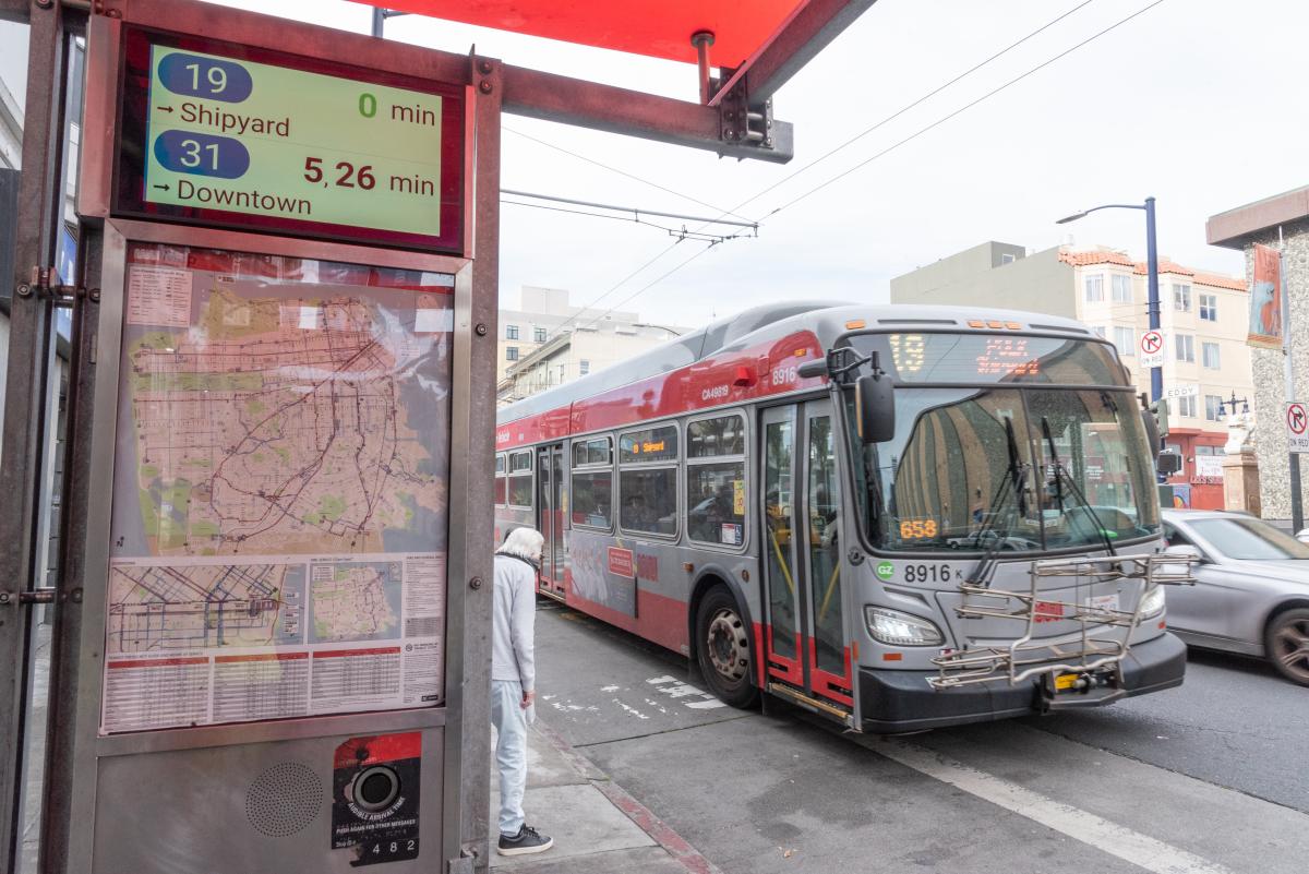
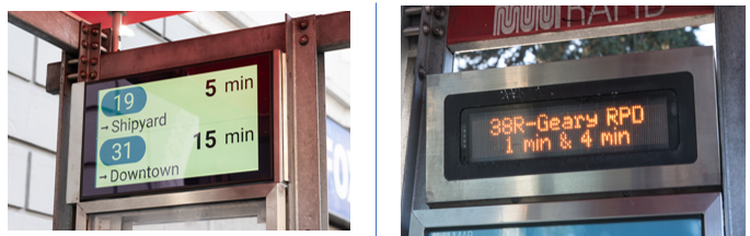
New Muni information screen at a bus shelter above Muni system map. New Muni service information displays are going into Muni shelters throughout San Francisco with updated features as part of SFMTA’s Next Generation Customer Information System upgrades.

As part of our Next Generation Customer Information System (CIS) project, we are installing over 800 new, larger Liquid Crystal Displays (LCDs) at Muni shelters and stations, replacing existing NextBus signs and expanding real-time information coverage. So far, we are over halfway to completion, with over 435 new displays installed in shelters. New screens show real-time multilingual information including graphics, maps and destinations.

Two displays being shown comparing the old versus new displays

New LCD displays (left) are replacing the previous Muni information displays (right).

Beginning this fall, Muni predictions on our new and improved Next Generation screens will include:

  • Crowding. On vehicles equipped with automatic passenger counters, displays will show how crowded they are.
  • Short-term route changes. We’ll be able to show planned short-term route changes, such as routing around special events. 

We are aiming to replace the remaining displays by the end of 2023. Additionally, we are working on new display locations with an emphasis on underserved neighborhoods, such as those identified by the Bayview Community Based Transportation Plan.

Learn more about the remaining display installation work, what’s next for our Next Generation upgrades and the many new features rolling out soon.

Get Real-Time Stop Information When Predictions Are Unavailable

Due to the nationwide AT&T 3G shutdown on June 8, NextMuni displays that use 3G modems no longer show information. We have been upgrading to 4G modems to continue to provide predictions while we roll out the new LCD display and prepare more significant system software upgrades.

For display locations remain impacted by the 3G shutdown, riders can obtain real-time stop information by using the stop ID number posted at the bus stop:

  • Online enter SFMTA.com/ followed by the stop ID number (no spaces). The stop at Market and 11th streets with stop ID 13245 can be found atSFMTA.com/13245
  • Text “NextMuni” and the stop ID number to 41411. For the stop at Market and 11th with stop ID 13245, send the text “NextMuni 13245” to 41411.
  • Call 511 and say “Departure Times” and the stop ID. For the stop at Market and 11th with stop ID 13245, say “Departure times 13245.”


Published November 02, 2022 at 10:51PM
https://ift.tt/hKdFilD

martes, 1 de noviembre de 2022

Central Subway Opens November 19 with Special Weekend Service

Central Subway Opens November 19 with Special Weekend Service
By Mariana Maguire

Map showing the existing Muni Metro system's J, K, L Bus, M, N and T lines with the new Central Subway connecting at Powell Station. The Central Subway goes to Chinatown-Rose Pak Station at Stockton and Clay, Union Square/Market Street Station at Geary and Stockton, Yerba Buena/Moscone Station at 4th and Folsom and 4th & Brannan Station at 4th and Brannan.

Central Subway special weekend service starts November 19 with service to Chinatown-Rose Pak Station, Union Square/Market Street Station, Yerba Buena/Moscone Station and 4th and Brannan.

On Saturday, November 19, the Central Subway makes its historic debut with special weekend service, Saturdays and Sundays, from 8 a.m. to 12 a.m. with trains every 12 minutes. During this special weekend service, customers will have a chance to ride through the new Central Subway for free and get to know the four new stations: Chinatown-Rose Pak at Stockton and Clay streets, Union Square/Market Street Station at Geary and Stockton streets, Yerba Buena/Moscone Station at 4th and Folsom and the new 4th & Brannan stop at 4th and Brannan streets.

During the special weekend service, customers can transfer to the new Central Subway service at Powell Station from Muni Metro and BART by walking underground to the new Union Square/Market Street Station.

The new Central Subway connects communities to destinations including Chinatown, Union Square, Yerba Buena Gardens, the Moscone Convention Centre, the Metreon and SFMOMA, just in time for the holidays.

Wayfinding Guidance

SFMTA ambassadors will provide wayfinding guidance online and in-person during special weekend service to help customers learn to navigate the new Central Subway stations and Muni Metro connections.

Online guidance will include a video that will be available on our website. Visit our Service Changes webpage (SFMTA.com/ServiceChanges) to learn more and sign up for a tour.

New T Third service in Central Subway is planned to start January 7

Beginning Saturday, January 7, SFMTA is planning to run the new T Third line service via Central Subway seven days a week, providing a direct connection from Chinatown-Rose Pak Station to Sunnydale. Weekday service will run from 6 a.m. to 12 a.m.. and weekend service will run from 8 a.m. to 12 a.m.. Stay tuned for more details!


Published November 01, 2022 at 07:38PM
https://ift.tt/SYve5GR

viernes, 28 de octubre de 2022

What’s new on the west side?

What’s new on the west side?
By Andrea Buffa

The west side of San Francisco is home to some of San Francisco’s most beloved recreational destinations — Golden Gate Park, the Presidio, Lake Merced, Fort Funston and Ocean Beach, among others. But many of these natural attractions — and others like Mt. Sutro and Twin Peaks — are also geographic barriers that can make travel to and from the west side of the city more difficult.

This may be one reason why three out of four people traveling within, to or from the west side do so by personal car. It’s also why we need to make sure there are more safe, reliable and affordable transportation options between west side neighborhoods and other citywide destinations.

This month we released an interactive website, San Francisco’s West Side on the Move, describing local experiences, transportation challenges and solutions in neighborhoods from the Richmond and the Sunset to Lake Merced, Parkside and West Portal. The website pulls together our latest efforts to make it safer and more convenient for people on the west side to get where they need to go. Our goal is for people who want to take Muni to have reliable and frequent service; for those who want to walk or bike to have safe streets; and for people who drive to face less congestion.

Beyond the geographic barriers that impede west side travel, other transportation challenges on the west side include street closures caused by construction projects and frequent closure of the Great Highway for sand removal. Street transformations that began during the pandemic, like Slow Streets and the closure of some roads in Golden Gate Park to cars, also altered some residents' trip patterns. We've been listening to and collaborating with community members on the west side about how to better address these challenges and meet their needs as well.

San Francisco’s West Side on the Move describes the solutions we’ve implemented or plan to implement soon on the west side. Our Transit team has already made major strides in improving west side Muni lines like the 38 Geary and 5R Fulton Rapid using tools like red transit lanes, bus bulbs and smart traffic signals. Travel times on the 38 Geary are up to 20% faster than they were previously, and travel times on the 5R Fulton Rapid are up to 12% faster. We’ve also improved travel times on the 1 California and the N Judah.

While the L Taraval Improvement Project is still in construction, it has already delivered important safety benefits. On the completed section of the L Taraval, which finished on time and on budget, pedestrian injuries decreased by 60%. Improvements like this are vitally important in all San Francisco communities, and especially so in this part of the city which is home to so many older adults and families with small children.

When it comes to reducing congestion, we are adjusting signal timing to keep up with changing traffic patterns, adding turn lanes and restrictions in key locations and providing more loading zones in commercial areas to reduce double-parking. We also monitor the network for opportunities to improve bottlenecks, such as the recently re-opened MLK Drive between Chain of Lakes Drive and Sunset Boulevard.

To slow down traffic on residential streets and make walking and bicycling safer and more enjoyable, we’re using traffic calming tools like speed bumps to slow vehicle speeds. In 2021, the SFTMTA invested in a comprehensive package of traffic calming measures in the Outer Sunset to address local concerns. Monitoring indicates that traffic speed and volume was reduced, which ideally creates safer conditions for all road users.

While the Slow Streets program has provided valuable, safe routes for people who walk, bike and roll, we've heard from residents that they're not working well for every community, particularly the Sunset. There, the Sunset Neighborways program is replacing Slow Streets to create a network of safe streets for active transportation. The emphasis of Sunset Neighborways will be on slowing down traffic to improve safety, rather than restricting it. In the Richmond, Anza Street is a key corridor for biking and active transportation, and in response to community requests for a better east-west bike route through the neighborhood, we added bike lanes and safety improvements like speed cushions to slow traffic and create a street that can be easily and safely shared by cyclists and drivers. 

By releasing San Francisco’s West Side on the Move, the SFMTA hopes to deepen its dialogue with west side community members about what’s working well and what can be improved when it comes to keeping the west side moving. Please share your ideas by emailing WestsideProjects@SFMTA.com

Should we say how important the decrease in pedestrian injuries is so significant given how many seniors and families with small kids live in the area?


Published October 28, 2022 at 11:19PM
https://ift.tt/ikDwOb4

martes, 25 de octubre de 2022

75 Years After the Battle to Save the Cable Cars

75 Years After the Battle to Save the Cable Cars
By Jeremy Menzies

Seventy-five years ago, San Francisco’s cable cars were viewed as more of a costly nuisance.  A few city leaders wanted to tear out the 1870s-era transit system of wooden vehicles towed by an underground cable system. Pioneer of civic activism, Friedel Klussmann led the charge to preserve this moving landmark that draws of visitors from around the world looking to fulfill their dream of riding the cable car over our hills.  

Friedel Klussmann founded the Citizens' Committee to Save the Cable Cars. The committee began a public campaign demonstrating that the cable cars’ value to San Francisco was far greater than their operational cost. As a result, the lines were saved and the cable cars became enshrined as a cultural icon of San Francisco. 

We will celebrate this anniversary with Market Street Railway and Mayor London Breed on October 26th at Market and Powell streets at 11am. Here’s a brief look at the events of 75 years ago and what Klussmann and her allies did to save the system. 

Transit Troubles 

In the mid 1940s, San Francisco’s transit system was undergoing major changes. The entire system was in poor condition following World War II. City officials and then Mayor Roger Lapham looked to reduce costs by replacing old worn rail lines with new buses. Included in this plan was the Powell Street cable car lines, which were scheduled to be replaced with buses in 1947. 

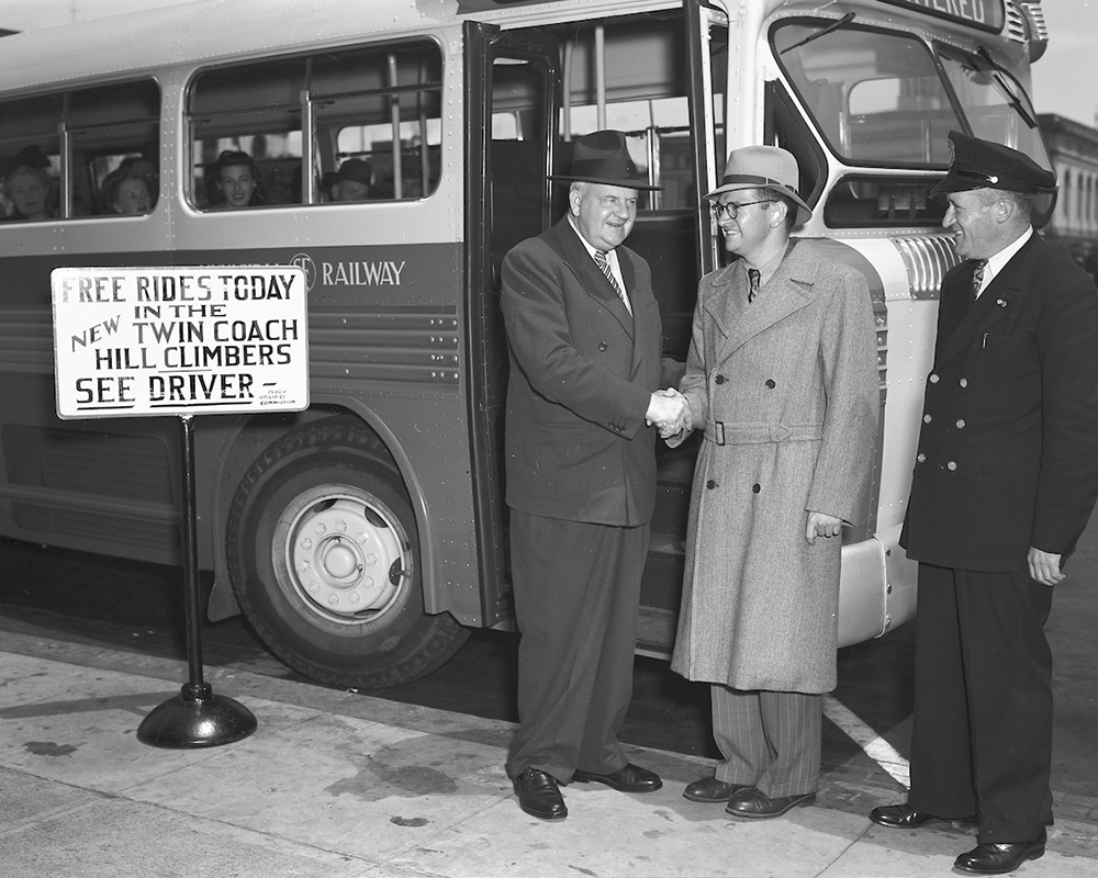
Three people standing next to bus, two people are shaking hands.

Mayor Roger Lapham (left) poses with a new Fageol Twin bus to promote his choice of vehicles to replace the cable cars. Touted as “hill climbers”, these buses had two engines in a unique and complex system to provide more power. 

Eyesore or Asset? 

Arguing against the cable cars, Mayor Lapham and transit officials said that they were too costly to repair and operate and could not provide adequate service. The officials were backed by business leaders in Union Square and downtown, who had major influence on city policy. While there were real financial considerations at play to repair the system, the cars were also seen only as ramshackle old junk heaps bleeding money. 

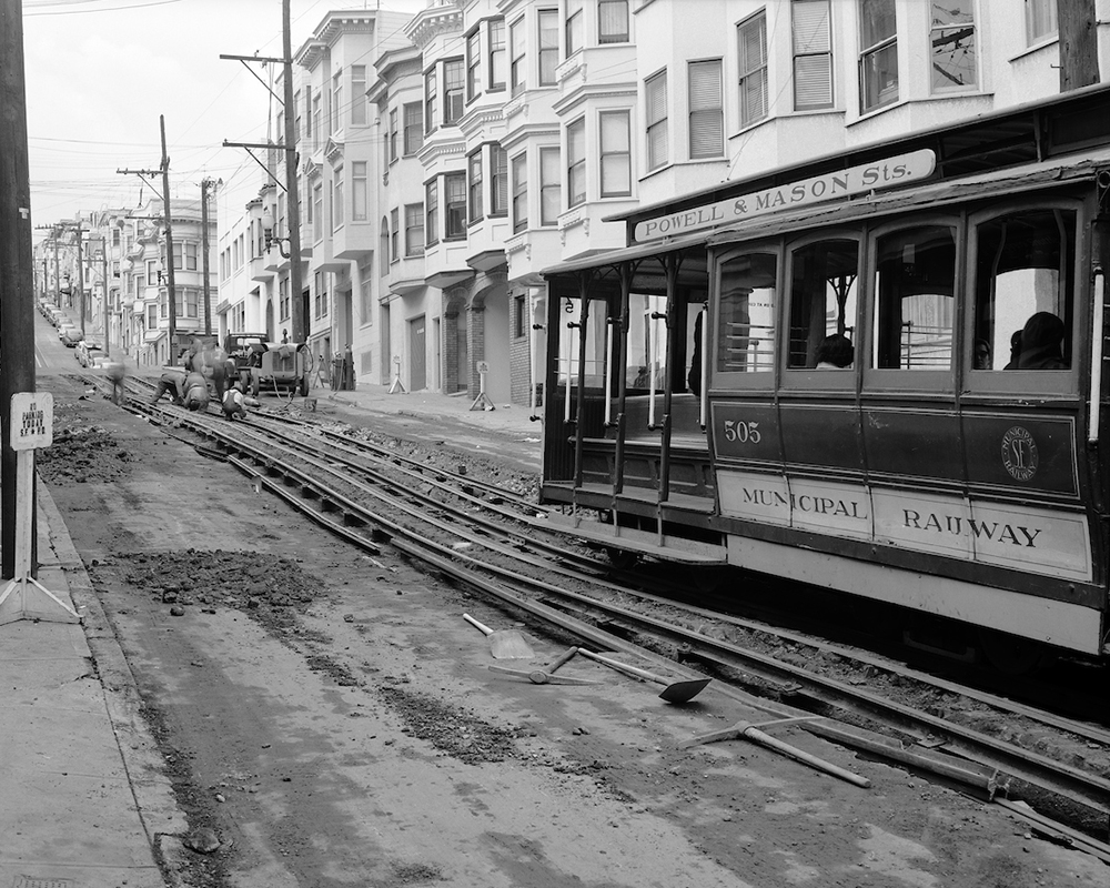
Construction work on cable car line showing exposed tracks and cable car running up street with people working in background

Taken in 1953, this photo demonstrates how much work was needed to rehab the cable car system following decades of deferred maintenance. 

In an era when Americans across the country abandoned transit for shiny new cars and freeways, it’s somewhat surprising that people in San Francisco wanted to keep the cable cars alive. To these people, the Victorian Era style and unique technology gave them value. San Francisco was the birthplace of the cable car and they were a living piece of the city’s history worthy of saving. 

Klussmann Rallies Women to Fight 

Spearheading the fight to save the cable cars was Friedel Klussmann and the Citizens’ Committee to Save the Cable Cars. Going head to head against the most powerful men in the city, Klussmann and her women-led group rallied to keep the cars on the road.  

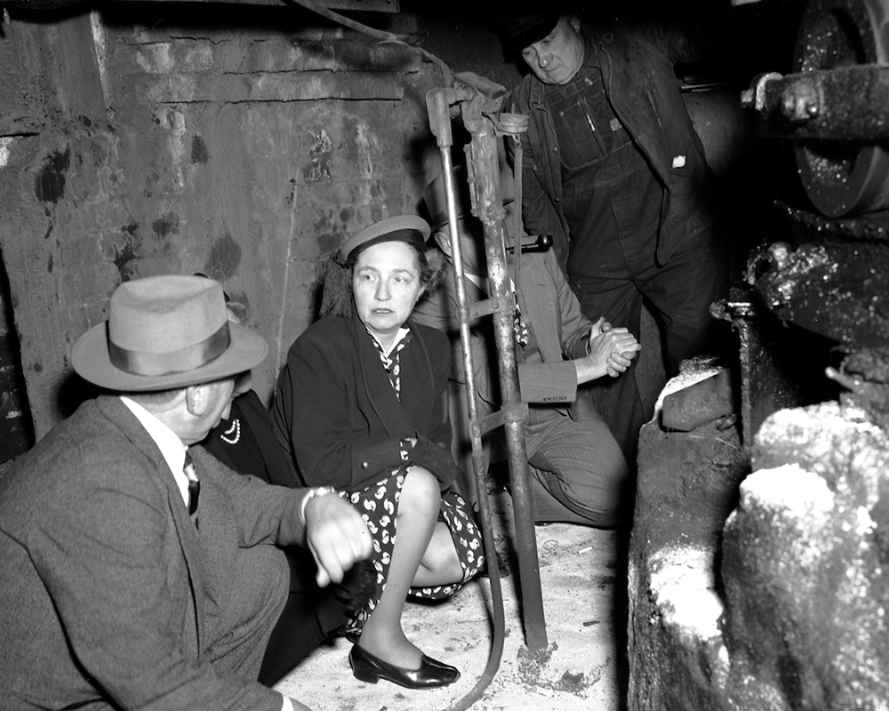
Three people crouching in dirty, small room underneath street with large pulley to run cable car cable

Friedel Klussmann (center) inspects the turntable underneath Powell and Market Streets. In her fight to save the system, she dug deep into the details to understand the problems involved in keeping them on the road. 

The group investigated the situation to get the facts and led campaign after campaign to spread the word and build support for the cars. Their work brought the issue before the voters in 1947 and the city was forced to retain the Powell lines. Two years later, another vote decided that the city would acquire the California Street Cable Railroad company, which ran lines on California, Jones, Hyde, and O’Farrell streets. By 1956, Klussmann and other activists had saved the cable cars but not without heavy losses. The system of five lines that existed at the beginning of the fight was cut and reconfigured into the three we see today. 

Fabric of the City 

Today, cable cars are as synonymous with San Francisco as summer fog and the Golden Gate Bridge. Not only do they provide transit service along busy corridors for locals, but they are one of the biggest visitor attractions. Each year, thousands of people from across the globe come to see and ride the cars. In 1966, the system was added to the National Register of Historic Places, enshrining them in American history.  

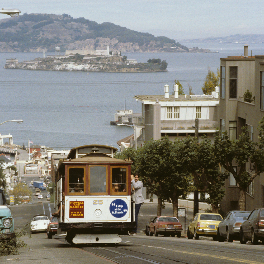
Color photo showing cable car 25 climbing hyde street with San Francisco bay and alcatraz island in background.

After the system was rescued by activists and bolstered by rehabs, the cable cars became a major attraction and led to increased development of Fishermen’s Wharf as a tourism hub. 

Muni’s historic preservation partner, Market Street Railway, covers this topic in much greater detail in their September blog


Published October 25, 2022 at 11:52PM
https://ift.tt/eXtFjQf

viernes, 14 de octubre de 2022

Paratransit Services 2022 Update

Paratransit Services 2022 Update
By Erin McAuliff

This past year, the SFMTA’s paratransit programs safely provided close to half a million trips to older adults and people with disabilities around San Francisco. These services provide door-to-door transportation to people unable to independently use the Muni system. They include SF Access Paratransit, Group Van service, Shop-a-Round shuttles, the Essential Trip Card Program (ETC) and the Van Gogh Recreational program.  

In addition to traditional van services, the SFMTA partners with the local taxi industry to provide cost-efficient and customer-friendly taxi options. Payment is accepted in every San Francisco taxi, including accessible ramp-equipped taxis, with the swipe of an SF Paratransit Taxi debit card.   

Here are a few accomplishments staff at the SFMTA and Transdev (the contractor responsible for managing SF Paratransit services) have been working on behind the scenes to improve our service offerings and continue to fill transportation gaps experienced by older adults and people with disabilities:

  • We bought 26 new paratransit vans with added safety features like audible right turn notifications to warn pedestrians and cyclists; automated safety technology that provides alerts to operators to avoid collisions; and DriveCam technology that records safety-related events.  When we retired our older vehicles, we took the opportunity to transfer three retired vehicles to the San Francisco Fire Department to support the Community Paramedicine Street Crisis Response Team and one retired vehicle to the SFMTA Customer Service Center to serve as its first Mobile Sales Van, bringing SFMTA services to the local community.
  • The Essential Trip Card program launched in April 2020 as a response to the pandemic. Since then, we have enrolled over 5,000 older adults and people with disabilities, providing over 160,000 taxi trips. In July, the program, and the SFMTA’s partnership with local non-profit Community Living Campaign, was featured as a case study for reducing isolation and improving health outcomes among older adults by the National Center for Mobility Management. Community Living Campaign provides full fare assistance to San Francisco paratransit riders in need.
  • Last year, we officially launched SF Access Online to allow riders to schedule their SF Access van trips online. We also launched SF Paratransit Taxi Online, which allows riders, including ETC customers, to pay for their monthly taxi fare allotment and track trip activity online.
  • San Francisco Paratransit Operations was part of the community emergency response team that organized and provided special services when the COVID-19 pandemic struck. Paratransit operators trained by Emergency Management Services (EMS), teamed up with EMS staff to transport vulnerable people to COVID-19 testing, treatment and shelter locations. The work was only assigned to drivers who volunteered, even at the beginning of the pandemic, when no one fully understood the risks of the virus. At its height of demand, 27 full-time drivers were dedicated to this service.
  • This past May, the SFMTA Board of Directors recognized the employees of SF Paratransit for all the work they have been doing, especially the work to innovate new programs that helped our passengers stay connected with essential services during the pandemic. The partnership with EMS also received the 2022 Innovative Practice Bronze Award from the National Association of City and County Health Officials.
  • SFMTA staff have been hard at work preparing for the integration and pilot of Clipper 2.0. SF Paratransit will be the pilot agency to test out using the next generation of Clipper Cards, allowing riders to pay for a paratransit van trip with Clipper for the first time ever. 

The SF Paratransit program also houses the Mobility Management Center, a one-stop-shop for older adults and people with disabilities to access transportation information, resources and referrals tailored to an individual’s needs. Mobility Management staff are available to answer individual questions by phone, email or in-person, or you can schedule an in-person or virtual group presentation for your organization.

San Francisco paratransit operations are funded by San Francisco’s half-cent transportation sales tax. As mentioned in our informational blog, in November voters will have an opportunity to decide whether to extend the sales tax for another 30 years and allocate 11% of the funds to paratransit. More information can be found in the Department of Elections’ Voter Guide under Proposition L or on the SFCTA Half-cent Sales Tax page.

San Francisco has proudly provided paratransit services since 1978, and we have never been more aware of how essential our programs are than during the past few years. We are so grateful for the work our paratransit staff has done and continues to do to serve older adults and people with disabilities in San Francisco.


Published October 15, 2022 at 12:08AM
https://ift.tt/NSbZowa

jueves, 6 de octubre de 2022

What’s in Proposition L?

What’s in Proposition L?
By Andrea Buffa

On November 8, San Francisco voters will decide whether to continue a half-cent transportation sales tax that has been funding city and county transportation projects since it was first enacted in 1989. Proposition L is not a tax increase but does require a two-thirds majority vote to pass.

The half-cent sales tax is administered by the San Francisco County Transportation Authority (SFCTA).  Proposition L would approve a new 2022 Transportation Expenditure Plan for how these funds will be spent for the next 30 years.

The 2022 Transportation Expenditure Plan will fund projects in these categories:

  • 41% for transit maintenance and enhancements: Funds Muni, BART, Caltrain and ferries. The money goes toward maintenance, rehabilitation and replacement of vehicles; station and access improvements; and planning for the next generation of public transit.
    • Examples: New buses and light rail vehicles, electrifying Muni’s bus fleet, maintaining buses and trains so they operate safely and reliably
  • 23% for major transit projects: Funds Muni bus and train reliability and efficiency improvements; increasing Muni and BART capacity; and major expansion projects
    • Example: The Caltrain Downtown Extension from 4th and King railyard to the Salesforce Transit Center
  • 19% for streets and freeways: Funds street repaving; walking and bicycling safety improvements; signals and traffic calming; and major street and freeway redesign planning
    • Examples: Neighborhood-level investments such as crosswalks, traffic calming, new and upgraded traffic signals, bicycle lanes and Safe Routes to School programs
  • 11% for paratransit: Funds the SFMTA’s paratransit service, which is a van and taxi program for people who are unable to independently use or access public transit because of a disability or disabling health condition
  • 6% for system planning and community equity: Funds transportation demand management; neighborhood and equity-focused planning and implementation
    • Example: Implementing improvements identified in community-based plans across the city and particularly in Equity Priority Communities

The SFCTA website provides more details on the 2022 Transportation Expenditure Plan.

In previous years, the sales tax has funded projects large and small, some of the well-known ones being the Salesforce Transit Center, the electrification of Caltrain (anticipated to be done in 2024), Muni Central Subway and reconstructing Doyle Drive, now known as Presidio Parkway.

It has also funded smaller projects like traffic calming, street repaving, protected bike lanes, new and upgraded signals and, during the pandemic, taxi rides home for essential workers.

To compete for federal and state grants, such as the funds in last year’s federal Bipartisan Infrastructure Law, San Francisco needs local funds that match the money from the grant. The sales tax funds are our main source of these matching funds. On average, we’ve leveraged every dollar in half-cent sales tax funding to attract $4 - 7 in additional funding from federal, state or other sources.

If Measure L does not pass, the half-cent transportation sales tax will continue to be collected until March 2034. However, the money can only be spent on projects that were included in the Transportation Expenditure Plan from 2003.

To learn more about the half-cent transportation sales tax, you can go to the SFCTA website.


Published October 06, 2022 at 10:32PM
https://ift.tt/3PA94IF

miércoles, 28 de septiembre de 2022

Celebrating BART at 50: A Critical Link for San Francisco

Celebrating BART at 50: A Critical Link for San Francisco
By Jeremy Menzies

This month, our sister agency BART, celebrates its 50th anniversary. BART service changed transportation in the Bay Area forever, connecting communities in a way that hadn’t been done before. For San Francisco, the construction of BART not only provided new travel options within the city and to the East Bay but also built the Muni Metro system.

Here’s a look at some of BART’s history through the SFMTA’s historic photos.

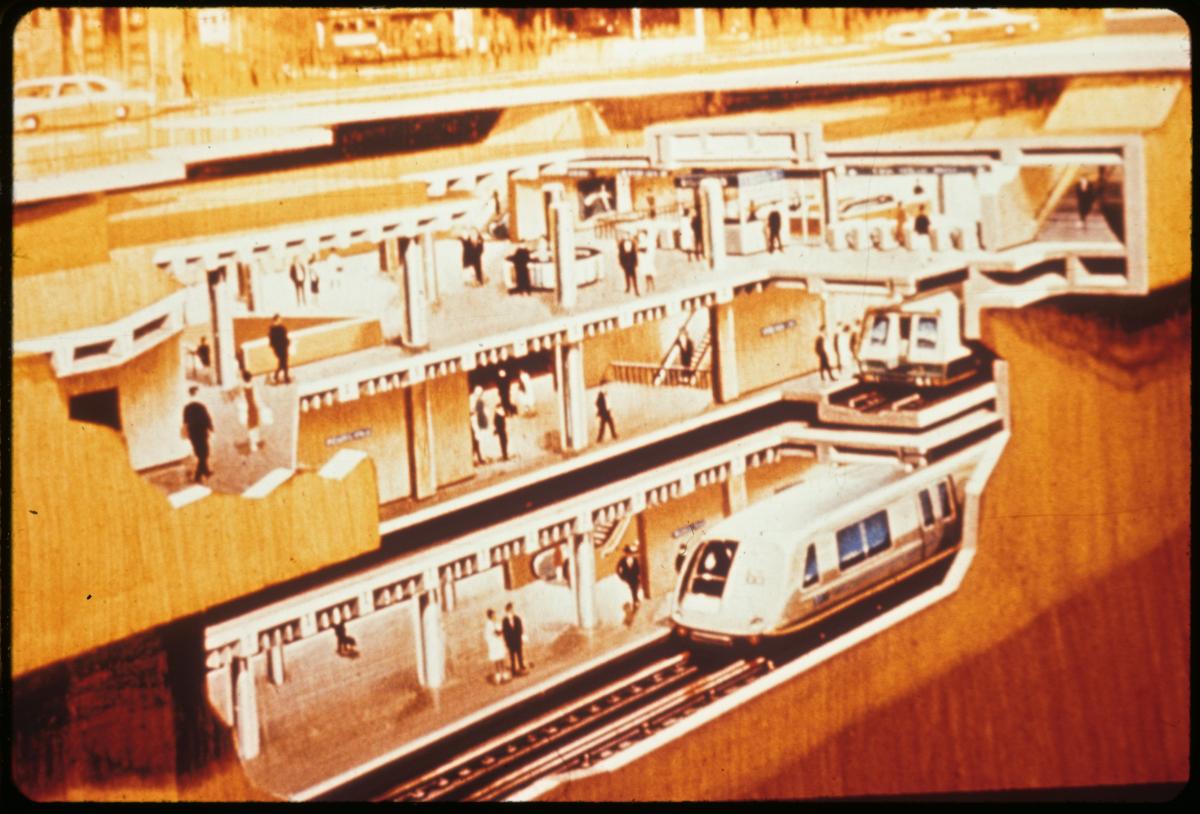
Image of cutaway drawing showing underground subway with Muni and BART trains insideThis conceptual drawing from around 1960 shows the combined BART and Muni Metro subway underneath Market Street at Powell.

The story of BART goes back decades before the opening in September 1972. It wasn’t until the early 1960s that a plan and funding were in place for BART to come to fruition.

Originally, five counties formed the Bay Area Rapid Transit District. In a 1960 engineering report, proposed route maps showed lines extending both north across the Golden Gate into Marin and south down the Peninsula to Palo Alto. After Marin and San Mateo counties withdrew from the district, a final plan was drawn up to serve mainly the East Bay and San Francisco.

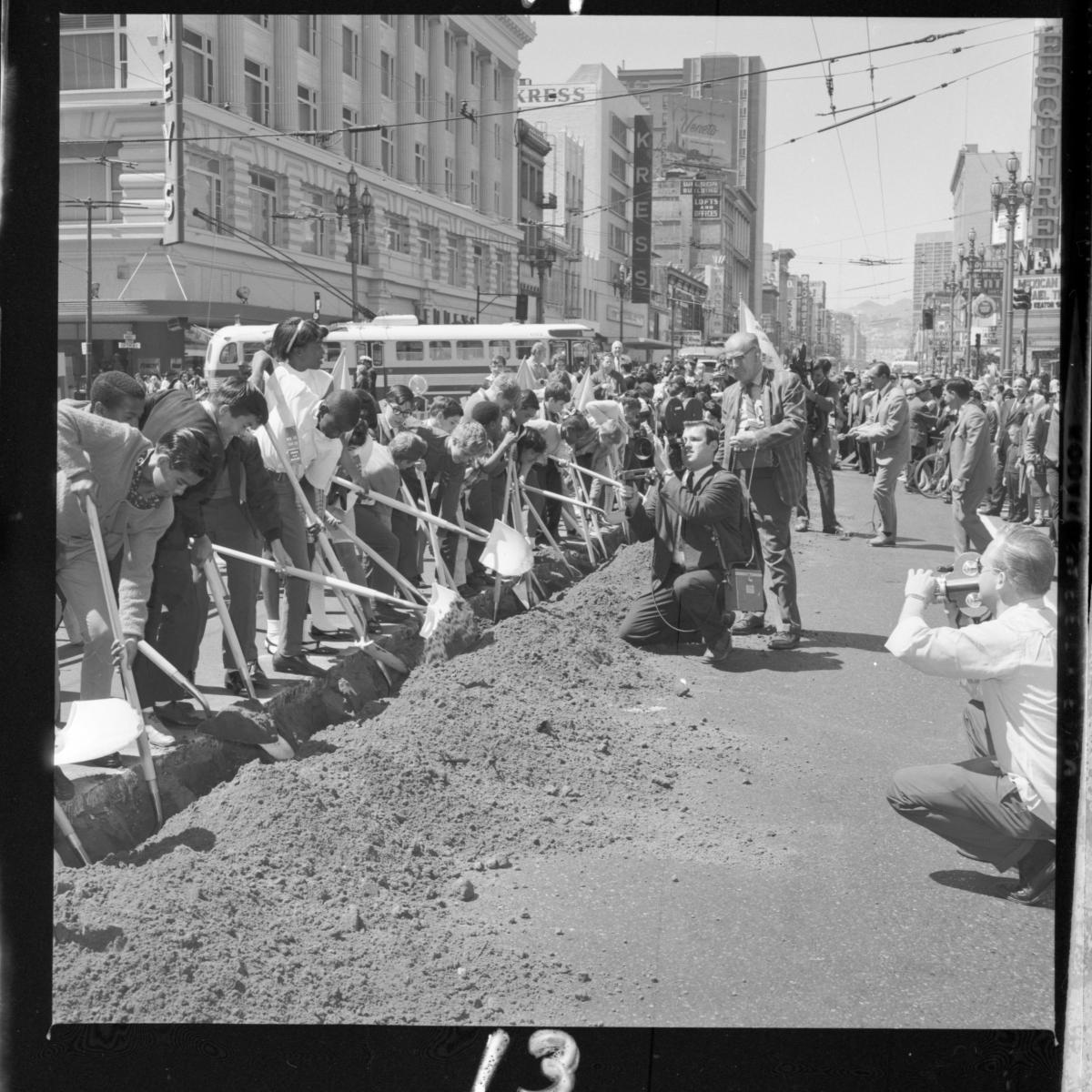
Black and white photo of a line of people digging with shovels in shallow ditch on Market Street

Students with white shovels were on hand for the groundbreaking ceremony for BART/Muni Metro at Market and Powell streets on July 25, 1967.

Groundbreaking on construction for San Francisco’s Market Street Subway took place in July 1967. This construction not only included the main BART stations downtown but also stations for Muni Metro at Church, Castro, and West Portal. Forest Hill Station was modified with new platforms and equipment to fit Muni’s incoming light rail vehicles. The funding and planning power of the BART District brought to life an idea that had been floated since at least 1913.

Color image looking east on Market and Collingwood streets showing excavation with streetcar passing over top of hole in ground

An overhead view looking at the construction of Castro Station in October 1973.

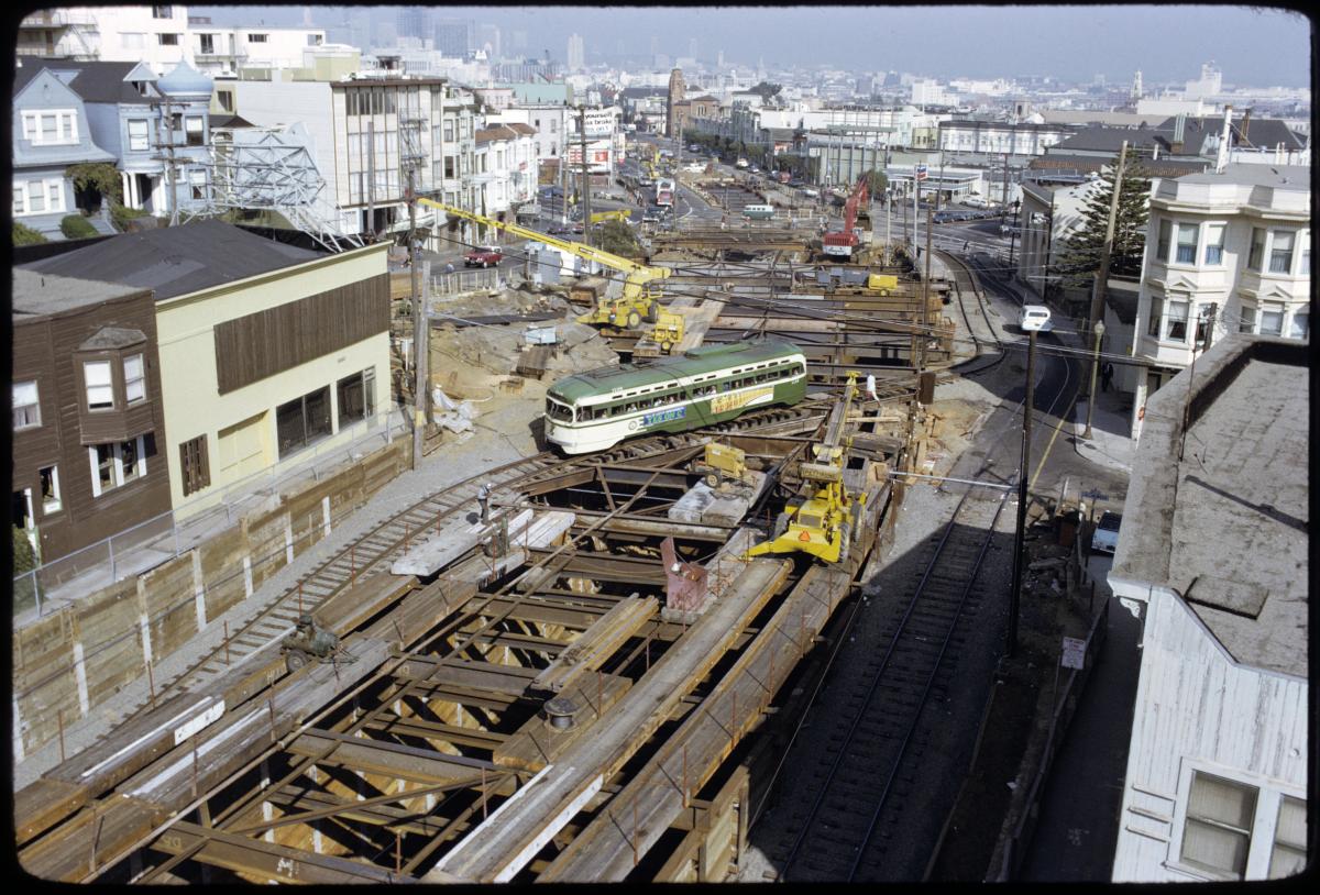
Construction along Market Street was extremely disruptive for the city’s busiest corridor. During construction, Muni streetcars and buses had to navigate constantly shifting reroutes, wooden plank roadways, and sinkholes on top of all the usual street hazards. One of the most dramatic engineering feats was a temporary bridge built over a huge open pit at Collingwood Street. Here, streetcars traveling towards West Portal crossed over top construction on Castro Station to enter the Twin Peaks Tunnel. The temporary ramps built to access the tunnel still exist today and are used for emergency and maintenance needs.

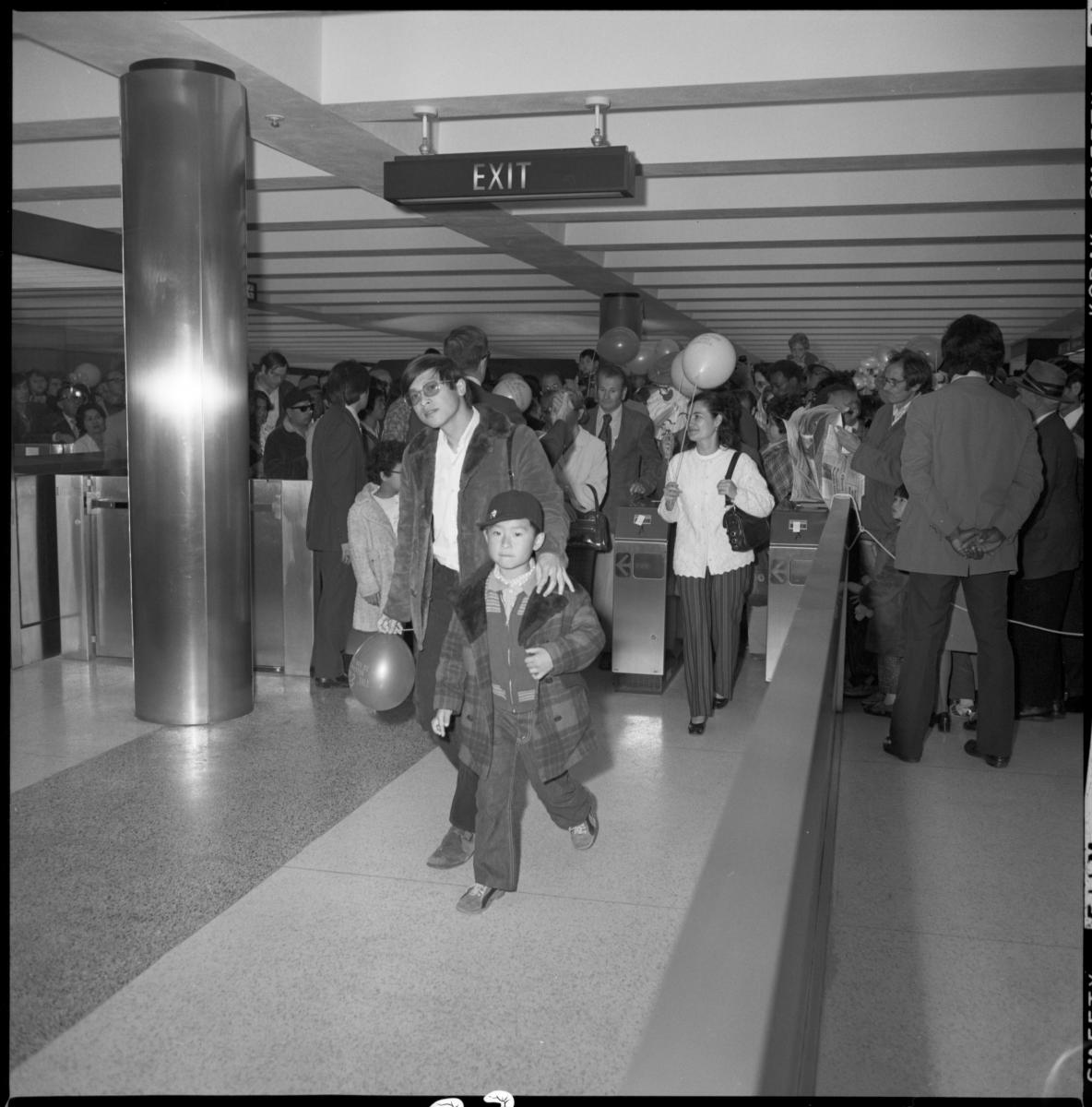
People entering fare gates inside station, some carrying balloons

The first passengers pass through Powell Station fare gates at the opening of BART in the city on November 3, 1973.

BART opened in San Francisco on November 3, 1973. For the first time ever, San Franciscans could travel from downtown to the outer reaches of the city on an underground subway system. Service across the Bay opened ten months later in September 1974. BART gave San Franciscans from Balboa Park to downtown improved access to jobs, shopping, and education as well as connections around the region.

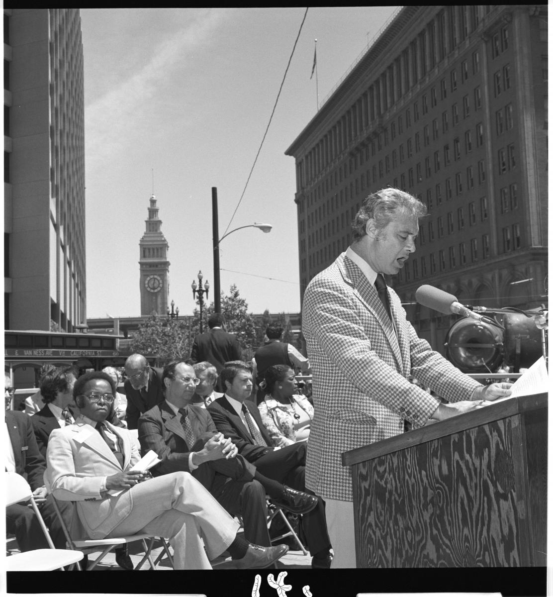
Mayor George Moscone speaking from podium with crowd of people, Ferry Building, and cable car in background

San Francisco Mayor Moscone speaks at the opening of Embarcadero Station at Market and Drumm Streets.

Embarcadero Station, which was not part of the original plan, was built after the main subway. It opened on May 27, 1976, with Mayor George Moscone giving a speech at the end of the California Street cable car line. Today, Embarcadero Station is the busiest in the system, with over 27,000 entries and exits logged in August 2022.

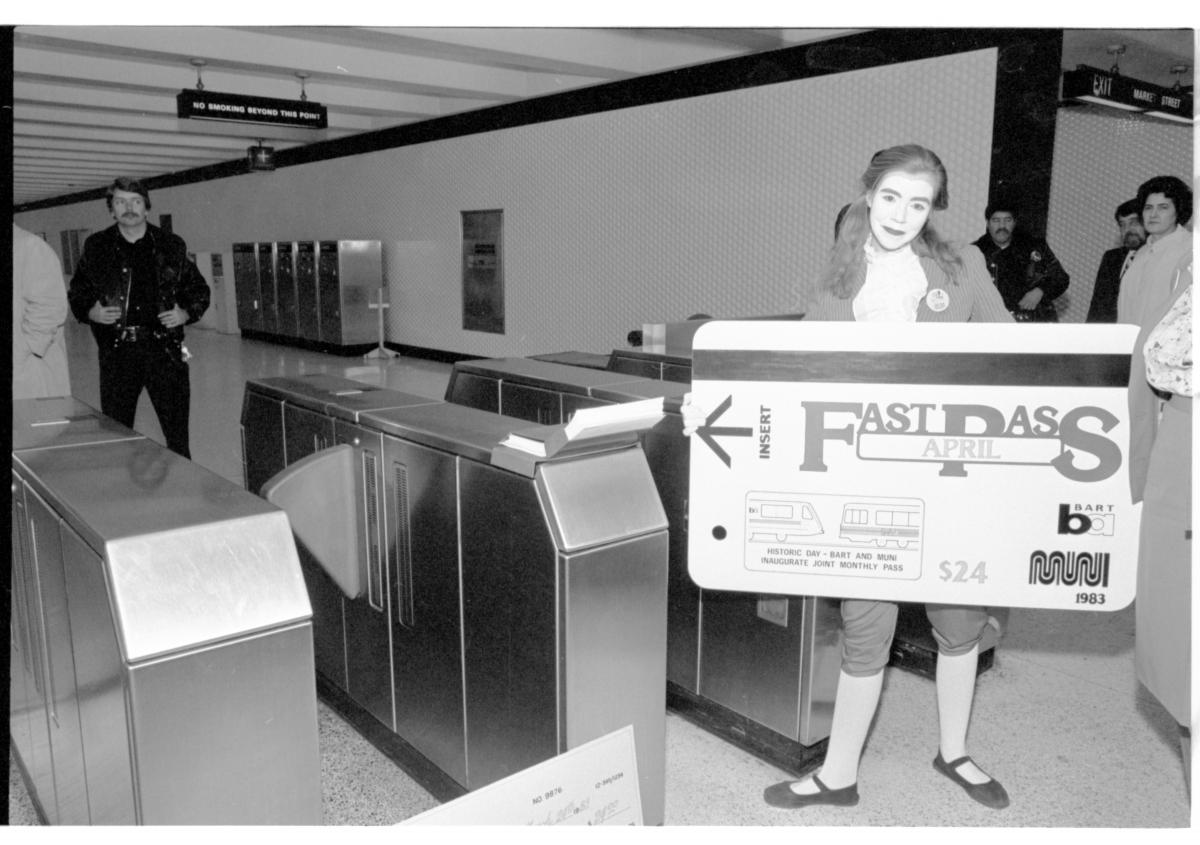
Person dressed as a mime standing next to fare gates holding large replica of Muni Fast Pass transit fare card.

A mime holds up an oversized Muni/BART Fast Pass in Powell Station at the launch of the program on March 24, 1983.

In the early 1980s, Muni and BART partnered to improve transit within the city through a combined Muni/BART monthly Fast Pass. Muni customers could ride BART between Embarcadero and Balboa Park on the same pass, making transfers between the two systems seamless.

Today, BART is a critical part of our regional transportation network. Construction of BART in the mid-century also brought better service to the hundreds of thousands of Muni Metro riders within San Francisco.

As one of our regional transit partners, we congratulate BART on their golden anniversary and look forward to another 50+ years of serving the Bay together!  Read more about BART’s first 50 years and check out some amazing historic documents and a timeline 1947-1991.


Published September 28, 2022 at 11:56PM
https://ift.tt/vm27BGp

Guía Definitiva de Marketing de Contenido: Estrategias y Mejores Prácticas

Guía Definitiva de Marketing de Contenido: Estrategias y Mejores Prácticas En el mundo digital actual, la calidad del contenido es crucial p...